© Jim Hutchison September 2007
Goodbye to Alberta... It was here I started using a 35mm camera seriously, enough so that it's now a part-time career. Weddings and portraits make up the bulk of my work, but my first love is shooting landscapes in Banff National Park. This sparked the idea of conducting photo tours for visitors to the area, and I took an interpreter's course with the Mountain Parks Heritage Interpretation Association. When conducting photo tours, I fell into a rhythm of locations I would bring my clients. I'll share it for the benefit of you photographers looking for a day or two of planned shooting. It is mostly based on a book published by a friend of mine, Darwin Wiggett, called "How to Photograph the Canadian Rockies". We struck up our friendship in 2003, when he asked for some preliminary editing help with the content, as well as some field testing of his chapter on Kananaskis Country. After going through all the chapters, I started visiting many of the places described in the book, then developed an Excel spreadsheet summarizing and classifying the locations by the best time of day and year for shooting. Send me an email if you'd like a copy.
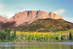
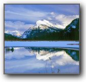
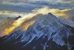
Photo Tour Destinations To get there from the Trans Canada Highway, head north on Highway 1X, which is at the west end of Morley Flats. Turn right at the �T� intersection, and a little over a kilometer east is the trailhead parking lot on the left. Walk along the service road to the west, and you�ll see a path off to the south about half a kilometer from the parking lot. The trail itself is a short 10-minute walk, which is well-worn, but there may be a few fallen trees to step over. It then opens up to a beautiful meadow just before you see the lake, suggesting the reason for it�s name. The location is at N51 06.965, W115 05.659. After sunrise, I'd then head to Banff townsite and take the gondola ride up Sulfur Mountain, a popular destination for tourists. The view at the top is outstanding, as it overlooks the Bow Valley. Look for Two Jack Lake (it's another prime spot for sunrise, offering an alternate view of Mount Rundle from the usual Vermillion Lakes), and Lake Minnewanka, a popular scuba diving destination. Back down from Sulfur Mountain, I'd then go around the Minnewanka loop, where more times than not we'd run across mountain goats. Following that, head towards Lake Louise via 1A along the Bow Valley Parkway. There are many places to stop for pictures, most notably being the Castle Mountain lookout, and Morants' Curve - especially when there's a train about to go by. Well worth the stop. Once at Lake Louise, check out the lake itself, then head up to Morraine Lake, a beautiful destination. Rent a canoe for an hour, but be careful you only take minimal gear in a splash-proof camera bag. Drive back down to Lake Louise and head up Hwy 93. There are numerous places for pictures, such as Hector Lake, Waterfoul Lakes, Mosquito Creek, Tangle Falls, Athabaska Falls, etc... all the way up to Jasper. To take everything in I've described, you really need two days minimum - I've highlighted the main ones I've used for photo tours that usually just last one day. My usual sunset location is Vermillion Lakes, just outside Banff townsite. The view of Mount Rundle is classic, and you will no doubt run into other photographers, as it is a Rocky Mountain icon.
Cheerio... A big "thank you" goes out to all my clients, and I now look forward to new people, geography, and opportunities in rural Ontario. Cheers,
|